|
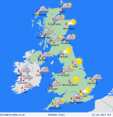 Thursday Thursday
An area of cloud and rain extends from southern Scotland, through western England, Wales and eastern Ireland on Thursday. Drier in much of central and eastern England with the winds increasing here. Showers following into the west of Scotland and Ireland, these turning to snow on the hills of central Scotland through the day. Tending to stay dry in eastern Scotland with broken cloud here. Highs at 5 to 7C.
 Thursday Night Thursday Night
A wet night across much of England and Wales. S front will be passing eastwards taking some heavy periods of rain with it, this turning to sleet and snow over high ground. Drer weather following to the north and west, although a few showers in western Scotland and Ireland. The rain arrives in southeast England later in the night with things turning coler to the north and west. Lows at 0 to 4C.
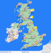 Friday Friday
A band of cloud and rain affecting eastern England on Friday morning, this perhaps turning to sleet and snow for a time. Drier and brighter weather arrives to the north and west and this edges slowly eastwards bringing sunny spells. Showers will be troubling western coasts and hills. The afternoon will be dry and bright for most, although still with a shower on western coasts. Highs at 3 to 5C.
 Saturday Saturday
A widespread frost on Saturday morning as a ridge of high pressure builds through England and Wales. Increasing winds over Scotland and Ireland ahead of a frontal system moving in from the Atlantic. This will be bringing rain, some of it heavy with a risk of gales in Sotland and northern England as the rain bands moves eastwards. The rain moves quickly east through the day bringing rain as far as eastern England by late afternoon. Highs at a slightly milder 4 to 7C.
|
