|
 Thursday Thursday
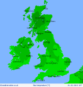
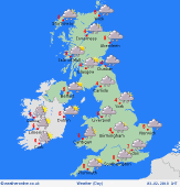
A cold day on Thursday with low pressure to the east. There will be frequent showers, mostly around western, northern and eastern coasts. The showers will be wintry with snow on hills, but perhaps at lower levels too. Away from the coasts it should be dry with sunny spells but will be remaining cold. Accumulations of snow are likely on the hills of Wales, northern England, Scotland and Ireland. Breezy for all with gales in Scotland making it feel even colder here. Highs at 3 to 7C.
 Thursday Night Thursday Night
A cold night with clear skies and mostly dry weather in the west, leading to a frost. There could be a shower on coasts and hills in the west at first, but these fading. To the eas it is going to be breezier, and although no frost there could be some ice as showers fall onto cold surfaces. Sleet and snow falling from the showers, especially on high ground. Lows near -1 to 3C.
 Friday Friday
Low pressure to the east on Friday with a ridge of high pressure building to the west. A frosty start in many northern and western areas. There will be a mix of sunshine and wintry showers in the east of Scotland and England, with some snow on hills. To the west it should be drier and brighter with sunny spells, although rain arrives with a front into western Ireland in the evening. Highs at 4 to 7C.
 Saturday Saturday
Low pressure to the north of Scotland on Saturday as a front passes eastwards. This brings periods of rain, some heavy on the hills and turning wintry in the north. Brighter weather will be following from the west, but showers associated with this brighter weather too. Rain may not clear eastern areas. A cold day with tops at 4 to 7C.
|
