|
Issued: 1000hrs Sunday 11th February 2018
Duty forecaster: Garry Nicholson
Frost some nights; temperatures around average
A general westerly pattern during the week ahead brings frontal systems in from the Atlantic, producing spells of rain, or snow over the hills. Locally, snow may briefly fall to low levels, but unlikely to stick for long. A mix of sunshine and wintry showers is likely to continue toward next weekend.
For the weather for the next few days click here
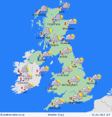
 Wednesday 14/02/18 Wednesday 14/02/18
Low pressure to the west of Ireland pushes fronts north & east across the British Isles. Widespread rain, heavy for a few hours. Possible snow on the leading edge of this system for northern areas, likely becoming confined to the hills. South to southwesterly winds, locally up to gale force around coasts. Temperatures 2 to 5C north, 7 to 10C south, mildest south-west.
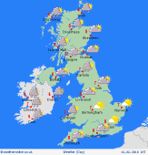
 Thursday 15/02/18 Thursday 15/02/18
Windy and cold, with strong to gale force westerlies across the country. Low pressure toward the north. A cold front will have cleared eastwards, leaving a chilly and showery pattern again, with snow and hail to low levels, most frequent in the west & north-west. Sunny spells away from showers. Highs 3 to 8C, mildest far south, but feeling colder in the wind.
 Friday 16/02/18 Friday 16/02/18
A similar chilly westerly pattern, with a mix of wintry showers and sunny spells. Snow and hail most frequent in west and north-western areas. Often dry with sunshine in central and eastern England. Frost and ice overnight. Highs 3 to 8C.
Saturday 17/02/18
A westrly flow is expected to continue. Wintry showers and some sunshine, perhaps dry for many places as pressure builds slowly from the west. Frost and ice in sheltered spots overnight. Highs 3 to 7C.
Sunday 18/02/18
High pressure to the south-west. Fairly quiet conditions. A few wintry showers, mainly northern areas. Frosty overnight. Highs 3 to 7C.
Monday 19/02/18
Confidence is low. On the cool side. Local wintry showers possible. A good deal of dry weather with sunshine. Starting frosty for some. Highs 3 to 7C.
|
