|
Issued: 0530hrs Tuesday 15th May 2018
Duty forecaster: Matthew Hugo
 High pressure will continue to dominate across Scandinavia and more northern areas of Europe into next week, otherwise low pressure persists for most. High pressure will continue to dominate across Scandinavia and more northern areas of Europe into next week, otherwise low pressure persists for most.
Tuesday
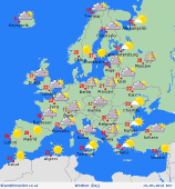
Into Tuesday and low pressure remains slow moving through much of Central Europe and this will maintain a risk of rain, showers or thunderstorms across parts of Germany, Switzerland, into much of France, more eastern areas of Spain and also through into central areas of Europe including Italy and surrounding countries. Some potentially severe thunderstorms could develop across parts of Italy during the day. Best of the weather will be across the British Isles and up towards Scandinavia still where pressure will remain higher with plenty of dry weather along with some bright or sunny spells. Very warm and humid across more eastern areas of the Med, including Greece and Turkey, and up into some eastern areas of Europe, but with afternoon thunderstorms and downpours possible.
 Wednesday Wednesday
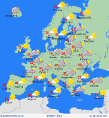
During Wednesday and high pressure will continue to build and dominate the weather across the British Isles, leading to further dry weather here with some sunshine. Equally, further mainly dry and settled weather is forecast across Scandinavia but with perhaps a greater risk of some patchy rain or showers across Norway. Low pressure does, however, remain slow moving across parts of Germany into Poland and other eastern areas of Europe bringing a risk of some heavy and perhaps thundery showers, and while some heavy downpours are possible across Italy conditions should be improved here than compared with Tuesday. Spain and Portugal is set fair withs ome sunshine but a cool N or NE'ly breeze is predicted here. Very warm and humid across more eastern areas of the Med, if not hot really across Greece and Turkey in particular, along with Cyprus, but with afternoon downpours and thunderstorms possible.
|


