|
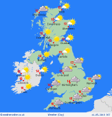 Thursday Thursday
A chilly start to this morning with a few mist and fog patches in more sheltered western and northern areas. There is still going to be a brisk north to northeast breeze across southeast England but for most the wind will be much lighter today. Plenty of sunshine develops during this morning and this will be lasting into this afternoon. Some sea breezes around the coasts with high cloud to the west. Highs at 16 to 19C for most of us.
 Thursday Night Thursday Night
A dry night with mostly clear skies. There may be some thicker cloud in the west of Ireland and this could produce a few spots of rain on coasts here. Other areas will be dry and become cold as temperatures fall in the light winds. Expect a touch of ground frost in sheltered areas by the morning, lows of 2 to 5C.
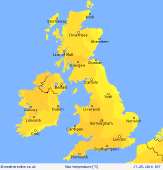
 Friday Friday
It's a fine start to Friday morning with high pressure centred over the top of the UK and Ireland. This should be bringing lots of sunshine after a chilly start. There may be more cloud in western Scotland and the north and west of Ireland as a weak occluded front pushes in bringing a few spots of rain with it. A low risk of an isolated shower over the hills of Wales, northern England and Scotland in the afternoon too. Highs at 16 to 21C for most.
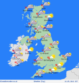
 Saturday Saturday
High pressure stays over the UK and Ireland on Saturday. This is set to bring another fine day with plenty of sunshine after a cool start. Thicker cloud and brisker southerly winds moving into western Ireland and the west of Scotland during the afternoon. Most areas enjoying a dry and fine day with sea breezes. Just a very low risk of an isolated shower over the Welsh hills and Pennines in the afternoon. Tops at 17 to 22C.
|
