|
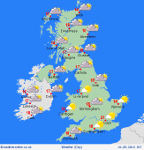 Saturday Saturday
A cool start to Saturday morning with a few mist and fog patches i sheltered areas. These soon clearing to leave a fine day with plenty fo sunshine and feeling warm too. Some sea breezes making coasts a little cooler. More cloud in western Ireland and western Scotland, but mostly dry here too with a moderate to fresh southwest wind. Highs at 22C inland, 15C on coasts.
 Saturday Night Saturday Night
Clear skies tonight combined with light winds will allow temperatures to fall quickly. A risk of a ground frost in protected areas of England and Wales. Increasing cloud in Scotland and Ireland as well as the west of Wales and western England. Some patchy drizzle affecting western Ireland and western Scotland. Lows at 4 to 7C.
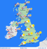 Sunday Sunday
High pressure stays to the east of the country on Sunday. Fronts to the west bring patchy rain to western Ireland and the west of Scotland. Some cloud too on western coasts and hills of Wales and int the far northwest of England. Dry with a fair amount of cloud in eastern Scotland. For England and Wales the day will be dry and warm once morning mist patches have cleared. An increasing breeze in the east. Highs at 23C in sunnier areas, 13C in western Scotland.
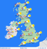 Monday Monday
A trough brings some showers to southeastern England early on Monday morning. These spread west during the day, some of them becoming locally heavy and thundery. Showers also developing over Wales and southwest England as well as northwest England and southwest Scotland, most in the afternoon. Eastern coasts may see some low cloud too. Sunshine between the showers and staying dry in eastern Scotland ad eastern England. Thicker cloud and some patchy rain in Ireland. Highs at 17 to 25C.
|
