|
Issued: 0900 Thursday 17th May 2018
Duty forecaster: Dr. Simon Keeling
Dry for many this weekend, but hints of cooler and showery weather for the east next week
Uncertainty over how conditions develop into the early stages of next week. Pressure is expected ot fall to the south of the country and this is likely to bring a chilly east wind with variable cloud and some rain or showers. Prior to this pressure is high bringing a mostly dry weekend for many with some good spells of sunshine, although some rain in the west.
 For the weather for the next few days click here For the weather for the next few days click here
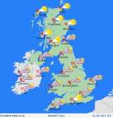
Sunday 20/5/18
A ridge of high pressure extends through most of eastern Scotland, England and Wales on Sunday from a high centred over Scandinavia. This brings another fair day with good spells of sunshine, although a more notable breeze on eastern coasts. Fronts moving into western areas bringing cloud and rain to western Ireland and the far west of Scotland, with increased cloud over western parts of England and Wales. Highs at 22C in central England, 12C in western Ireland.
 Monday 21/5/18 Monday 21/5/18
Pressure stays high overall on Monday as the flow becomes rather slack. Weak fronts in Ireland and western Scotland probably giving cloud and some light outbreaks of rain here. There is also the risk of some cloud and outbreaks of rain spreading through central and eastern England, although confidence is low. Drier to the west. Highs at 15C in cloudier parts of Scotland and Ireland, 22C in central and southern England.
 Tuesday 22/5/18 Tuesday 22/5/18
Low pressure stays south of the UK on Tuesday with higher pressure to the north. However, the easterly flow may allow for more cloud to affect many central and eastern areas with the risk of some rain in the east too. Western parts tending to be drier and breezy with the best of the sunshine here. Highs at 12C on eastern coasts in the stuff breeze, 20C in the west.
Wednesday 23/5/18
Little change on Wednesday with lower pressure to the south and higher pressure to the north leading to and east or northeast flow. This brings cloud and the threat of some patchy rain or showers, mostly in central and eastern areas. The best sunshine in the west. Confidence is low in the detail. Highs at 14 to 19C with a cold wind affecting eastern areas.
Thursday 24/5/18
A slack pressure flow over the country on Thursday. Sunny spells and a few showers affecting central and southern areas, perhaps some thicker cloud and rain in northwest Scotland. Elsewhere dry with sunny spells. Highs at 16 to 20C.
Friday 25/5/18
Hints of a mor western flow in northern areas on Friday. This could bring some rain to the northwest of Scotland. A ridge of high pressur to the south keeps the fair weather here. Highs at 13 to 20C.
|
