|
A very warm and humid period of weather with some sunshine, but also with some heavy showers or thunderstorms in places too
For the weather for the next few days click here
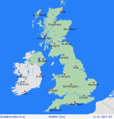
Monday 28/5/18
During BH Monday and further very warm and rather humid conditions are forecast to continue. N England and especially Scotland will maintain a lot of dry weather with plenty of sunny spells. However, more central, southern and south-western areas of England and Wales are likely to be at risk of some heavy showers or thunderstorms, at times, during the day. winds E or SE'ly light or moderate. Highs 16C to 24C, lowest temps near to the east coast.
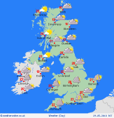
 Tuesday 29/5/18 Tuesday 29/5/18
Into Tuesday and at the moment warm or very warm and humid conditions will continue across many areas but with pressure continuing to fall then there may well be a greater risk of some heavy showers or thunderstorms developing almost anywhere during the day. Scotland, however, may maintain mainly dry and sunny conditions as high pressure persists just to the north and north-east. Winds E or SE'ly light, but variable inland. Highs 16C to 24C, lowest temps near to the east coast.
 Wednesday 30/5/18 Wednesday 30/5/18
While there are some uncertainties over the details by next Wednesday more unsettled are possible nationwide with many areas at risk of seeing some showers and these still potentially heavy and thundery as the day progresses too. Still warm and humid mind and with light and variable winds, especially inland. Temperatures near average, highs 16C to 23C.
 Thursday 31/5/18 Thursday 31/5/18
At the moment very similar weather conditions will continue into Thursday with many areas experiencing some drier and brighter, if not sunnier weather at times, but there will be an on-going risk of some heavy showers or possible thunderstorms at times too, these perhaps focused across England and Wales. Highs 16C to 23C.
Friday 01/06/18
Uncertainties by next Friday but there is some evidence that pressure may begin to rise once again so while some further heavy showers or isolated thunderstorms may still be possible, Friday may well progress towards drier conditions with some bright or sunny spells, perhaps especially across more northern and western areas of the British Isles. Many areas still maintaining warm or very warm weather too. Highs 15C to 21C.
Saturday 02/06/18
At the moment high pressure may well have returned by the following Saturday and this could well mean a mainly dry day for most areas with some bright or sunny spells. There is evidence to suggest low pressure may be close by just to the south-west, so some isolated heavy showers or thunderstorms may still be possible though across far southern and south-western regions, but many areas having a mainly dry conditions. Still warm or very warm. Highs, 15C to 21C.
|
